
Fremd 7 Day Forecast: Week of 3/29/2021
March 28, 2021
Summary/Highlights:
A warm farewell to March and a chilly start to April is expected this week as temperatures take a rollercoaster ride throughout the week. Thankfully, no precipitation is likely throughout the week which should make the large spread in temperatures more manageable. Since a number of religious holidays take place this week and weekend, the dry weather is much appreciated and will allow outdoor gatherings. On Monday, expect clear skies and warm temperatures! Winds will begin to ramp up Monday night as a storm system approaches, bringing continued warm temperatures and some clouds for Tuesday. The storm system will shift north Tuesday, leaving us precipitation free as the cold front moves through Tuesday night. Cold temperatures then move in for Wednesday and Thursday, though sunshine continues for the most part. Friday will start the warming trend as warmer temperatures begin to move northward out of the Plains and lower Mississippi Valley, with an increase in wind gusts possible. The weekend will feature beautiful temperatures and conditions, with current forecasted temperatures possibly being too conservative. Only time will tell, however, if we can make it close to 70 degrees for the weekend!
Daily Forecast:
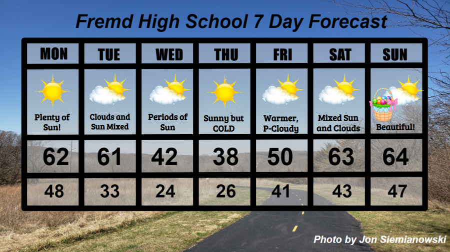
Monday 3/29: Mild temperatures and clear skies will make for a beautiful and sunny day! Winds will be on the increase into the nighttime, perhaps gusting to 40 mph at times. High temperature of 62° with a low temperature of 48°.
Tuesday 3/30: Partly cloudy skies and warm temperatures during the first part of the day will lead to increasing clouds and a drop in temperatures for the afternoon as the cold front moves through. During the evening, expect temperatures to continue falling and thinning clouds. Gusty winds to 35 mph will be possible for the first part of the day before the front comes through. High temperature of 61° with a low temperature of 33°.
Wednesday 3/31: Periods of clouds and sun along with much colder temperatures compared to Tuesday. High temperature of 42° with a low temperature of 24°.
Thursday 4/1: Sunny skies likely along with much below average temperatures. Cloudy conditions will be present over Lake Michigan throughout the day, and may drift in from time to time in the eastern sky. High temperature of 38° with a low temperature of 26°.
Friday 4/2: Much warmer temperatures closer to average along with mixed clouds and sunshine will be the story throughout the day, though periods of increased cloudiness are possible at times, most likely during the afternoon. High temperature of 50° with a low temperature of 41°.
Saturday 4/3: Partly cloudy skies and much warmer temperatures likely. Temperatures could be too conservative, so temperatures nearing 70 degrees could be possible depending on the evolution of a storm system near the Rockies over the weekend. High temperature of 63° with a low temperature of 43°.
Sunday 4/4: Continued mild temperatures along with partly cloudy skies are likely. The potential exists again for warmer temperatures than currently forecast, though that depends again on the evolution of a storm system over the weekend. High temperature of 64° with a low temperature of 47°.
National Weather Headlines:
A storm system coming out of the northern Rocky Mountains on Monday will pose a threat for fire danger across portions of the High Plains and Midwest Monday into Tuesday as wind gusts to 60 mph and low humidity create dangerous conditions for fire spread.
A low risk of severe thunderstorms will be possible on Tuesday across portions of the lower Mississippi Valley, otherwise a very quiet period for severe weather is likely throughout this week. This is relief to many, considering the past two weeks of widespread severe weather throughout the southern and eastern United States. Over an 8 day period, the NOAA Storm Prediction Center issued two “HIGH” risks for severe weather across the southern United States in any of the same areas. These “HIGH” risk levels are extremely rare, being level 5 out of 5 on the scale of likelihood for severe weather and tornadoes.