
Fremd 7 Day Forecast: Week of 2/8/2021
February 21, 2021
Summary/Highlights:
A frigid week is in store for Chicagoland as we head into the second full week of February. Multiple small disturbances in the atmosphere will keep clouds as well as snow chances locked in for all of the week, except for Tuesday. On Monday, clouds will be a common sight with the chance for some light snow in the morning, and more likely in the evening, with up to a couple inches of accumulation possible. Tuesday will easily be the best day of the week, with sunshine and slightly warmer temperatures. For late in the week, expect periodic snow chances as well as temperatures nearing 20 degrees at times, before temperatures plummet as another arctic blast enters just in time for the weekend. Dangerously low temperatures and wind chills will be possible, along with periodic chances for light snowfall. Keep in mind that while all snowfall in the coming week will be light in terms of accumulation, the numbers could add up to several inches in total as we head into next week. Another important note to stress is that while all of these small disturbances riding along the base of the arctic airmass currently in place look to be rather insignificant, it is possible for any of these storm systems to become a more significant one. With such a deep freeze and current high snow depth in place, along with the potential for additional snowfall accumulation, many climatologists are looking ahead to spring which could feature some flooding concerns. Below normal temperatures, perhaps significantly below normal at times, are forecast to remain in place next week and likely into the end of the month along with periodic chances for snow.
Daily Forecast:
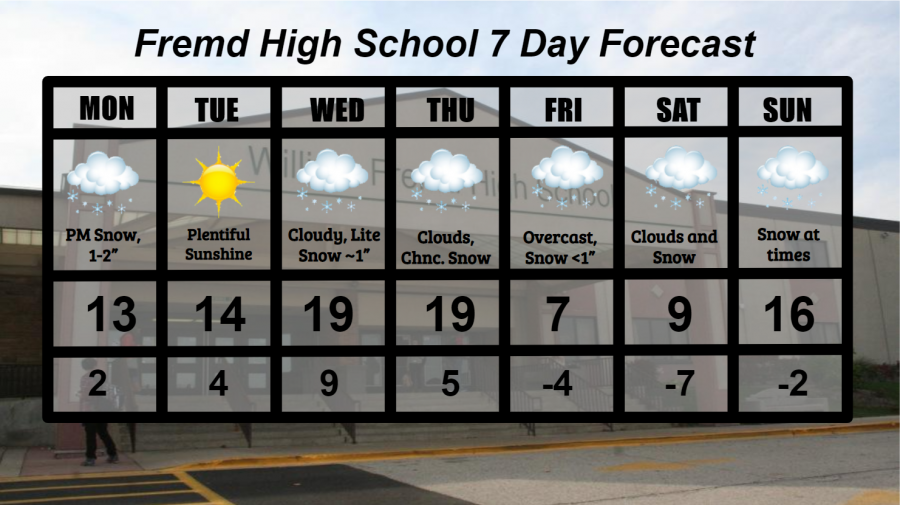
Monday 2/8: Cloudy conditions with some light snow in the morning will lead to a more substantial snow towards evening. 1 to 2 inches of snowfall accumulation is likely. Snow and cold temperatures will likely create hazardous road conditions, as chemical road treatments don’t work as well in frigid temperatures. High temperature of 13° with a low temperature of 2°.
Tuesday 2/9: Slightly warmer, yet still cold, with plentiful sunshine will easily make this the keeper of the week. High temperature of 14° with a low temperature of 4°.
Wednesday 2/10: Cloudy conditions and warmer temperatures will lead to periods of snow by nightfall. High temperature of 19° with a low temperature of 9°.
Thursday 2/11: Continued warmer temperatures and clouds, eventually leading to periods of light snow at times. High temperature of 19° with a low temperature of 5°.
Friday 2/12: Still cloudy, though much colder, with a chance of light snow showers. Wind chills may approach dangerous levels. High temperature of 7° with a low temperature of -4°.
Saturday 2/13: Frigid temperatures and cloudy conditions may lead to some snow, more likely at night. Wind chills may approach dangerous levels. High temperature of 9° with a low temperature of -7°.
Sunday 2/14: Slightly milder, though still cold temperatures are likely with a chance for snow throughout the day. High temperature of 16° with a low temperature of -2°.
National Weather Headlines:
While parts of Alaska and the southwestern United States see above normal temperatures, the rest of the United States is likely to experience a strong arctic blast as the polar vortex makes a visit. Temperatures and wind chills may approach dangerous levels, especially in portions of the northern and High Plains where wind chills lower than -50° have already been experienced this past week.
Multiple snow chances will be possible for those on the outside of the arctic airmass, wherever it sets up. These small disturbances may lay down a quick 1 to 2 inches each, though there is an outside chance that any of these systems could become more significant and drop heavier snowfall amounts, especially given the fluffier nature of the expected snowfall.