
Fremd 7 Day Forecast: Week of 12/14/2020
December 16, 2020
Summary/Highlights:
A very “normal” week by December standards is shaping up as we enter into the second half of the month. Periods of sun throughout the week juxtaposed with overcast conditions at times, particularly during the middle of the week and for the first part of the weekend, should make for a fairly decent week. Chilly temperatures to start the week will moderate to near average during the middle of the week, and eventually to above average readings for the weekend. While precipitation chances this week are generally expected to be low, the potential exists for some afternoon showers on Saturday 12/19. Periods of a rain/snow mix will also be possible as temperatures remain in the 30s. The National Weather Service (NWS) Climate Prediction Center (CPC) is forecasting continued above normal temperatures for next week as well as near normal precipitation chances. It is important to note that above average temperatures in December do not eliminate any snow potential, as snow starts becoming increasingly likely towards this time of the year.
Daily Forecast:
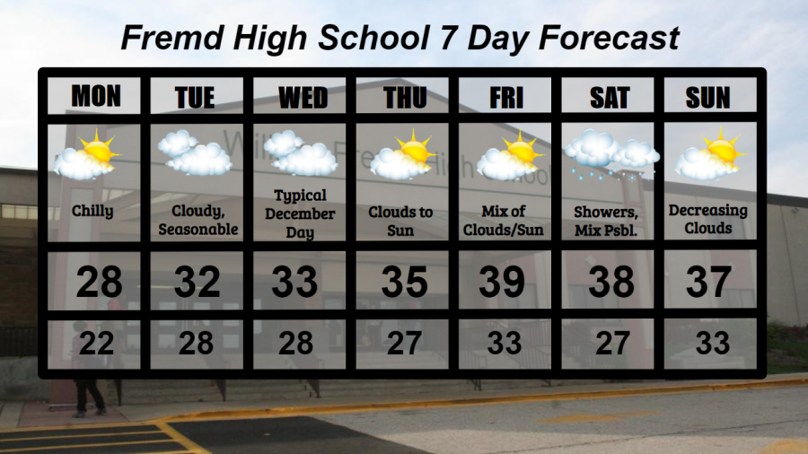
Monday 12/14: Chilly conditions likely with temperatures below average and clouds mixed with sun at times. High temperature of 28° with a low temperature of 22°.
Tuesday 12/15: Generally cloudy skies expected with the potential for a few peeks of sun and temperatures near average. High temperature of 32° with a low temperature of 28°.
Wednesday 12/16: Nearly a carbon copy of Tuesday with overcast conditions and temperatures near freezing. High temperature of 33° with a low temperature of 28°.
Thursday 12/17: Clouds early will lead to much more sun during the afternoon hours and slightly warmer conditions. High temperature of 35° with a low temperature of 27°.
Friday 12/18: Mixed clouds and sun at times, definitely the keeper of the week. High temperature of 39° with a low temperature of 33°.
Saturday 12/19: Increasing clouds with periods of rain showers possible throughout the afternoon and evening. The potential exists for a mix of rain and snow at times as temperatures remain in the 30s. High temperature of 38° with a low temperature of 27°.
Sunday 12/20: Decreasing clouds will give way to partly or mostly sunny skies by afternoon. High temperature of 37° with a low temperature of 33°.
National Weather Headlines:
Believe it or not, crippling California wildfires continue to burn across the state, creating hazardous air quality and threatening thousands of homes. These wildfires have already caused over 2 billion dollars in damage and have burned over 4 million acres of the state so far this year.
The northeast United States is likely to see two storm systems this week, the first occurring Monday into Tuesday, and the second occurring Wednesday into Thursday. A few inches of snow are likely in some areas from the first weather system, followed by potentially significant snow accumulations and strong winds from the second system. Current weather model estimates predict one to two feet of snow will be possible in some areas. However, it is important to note that weather models have been known to produce higher snowfall accumulations days before an event, and start backing off on those numbers closer to that event. This has especially been more of the case so far this winter season as weather model data has been negatively impacted by shutdowns from the Coronavirus, owing to overall less accurate model predictions.