
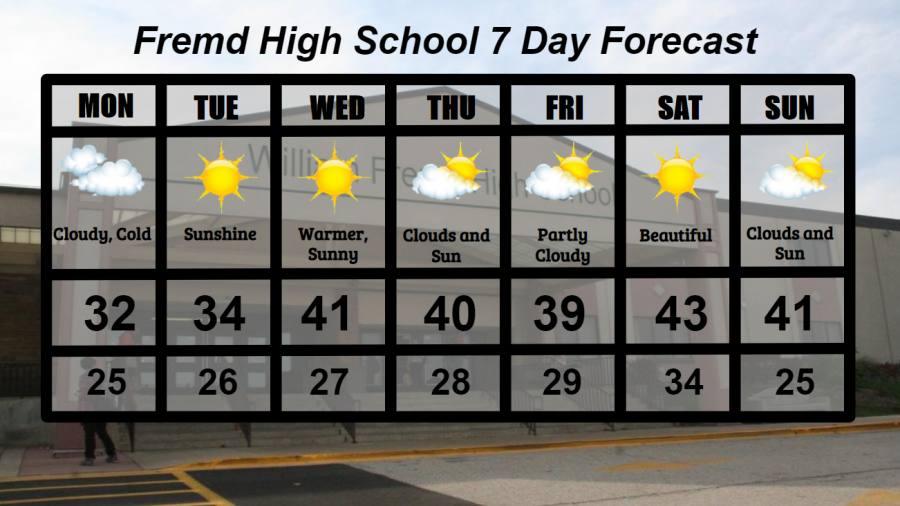
Fremd 7 Day Forecast: Week of 11/30/2020
December 1, 2020
Summary/Highlights:
A cold and gloomy start to the week will lead to periods of sun and clouds through the weekend. Temperatures in the low 30s early in the week will jump to near average temperatures of around 40 degrees for the remainder of the week and the weekend. A storm system will track south of the area on Thursday bringing an increased chance for clouds if the track of the storm shifts north. No major storm systems are in the forecast, and no precipitation is expected over the next week.
Daily Forecast:
Monday 11/30: Overcast skies early may lead to some peeks of sunshine later in the day. High temperature of 32° with a low temperature of 25°.
Tuesday 12/1: Continued cold with mainly sunny skies. High temperature of 34° with a low temperature of 26°.
Wednesday 12/2: Plentiful sunshine with a few passing clouds. High temperature of 41° with a low temperature of 27°.
Thursday 12/3: Mixed clouds and sun throughout the day. High temperature of 40° with a low temperature of 28°.
Friday 12/4: Partly cloudy skies will make for a chilly, but beautiful day. High temperature of 39° with a low temperature of 29°.
Saturday 12/5: Warmer temperatures and sunny skies will create a gorgeous day. High temperature of 43° with a low temperature of 34°.
Sunday 12/6: Continued average temperatures with mixed clouds and sun at times. High temperature of 41° with a low temperature of 25°.
National Weather Headlines:
Monday marks the final day of hurricane season in the Atlantic Basin, but tropical activity may not be entirely done. There is a chance for a storm to develop into a tropical system, but only time will tell if and when it may. The good news, however, is that there are no tropical threats to the United States.
A large storm system is expected to form early in the week and affect portions of the Ohio Valley, Northeast, and Michigan on Monday and Tuesday. While many of the details of this storm have yet to be worked out, there will likely be a snowy side to the storm with the potential for greater than six inches of snow in some areas. In addition, lake effect snow will be possible in northern Indiana and southwest Michigan where winds look to be favorable for snow showers. Lake effect snow can be highly unpredictable and vary drastically by location. Therefore, Winter Storm Watches have been issued for Monday and early Tuesday as snowfall amounts of greater than six inches and blowing snow are possible in these areas.