
Fremd 7 Day Forecast: Week of 4/19/2021
April 22, 2021
Summary/Highlights:
A rollercoaster ride of a week is expected as we head into the third full week of April. Instead of warm and pleasant spring weather, this week is likely to feature a lot of clouds as well as below to significantly below average temperatures. Additionally, periods of rain and even snow can be expected throughout the week. On Monday, expect generally overcast skies with the potential for showers during the morning hours as a front swings through, bringing colder air into the area. By Tuesday, an approaching storm system in conjunction with the existing cold air in place will yield a period of snow for most of the day, and potentially enough to accumulate up to around an inch. Given the warm surface temperatures over the past week as well as high temperatures near 40 degrees on Tuesday, the snow is not likely to lead to any major problems, though travel may still be hazardous at times if visibility is temporarily reduced. Temperatures should be able to fall into the upper 20s by Wednesday morning, which could meet criteria for a hard freeze, harming or killing unprotected vegetation outdoors. For the late half of the work week, temperatures will be on the increase with periods of clouds and sun. It won’t be until Friday night that the next chance of precipitation enters the picture, this time in the form of rain. Showers and perhaps a steady rain at times may linger into Saturday afternoon before dry conditions take hold once again. Late weekend into next week appears likely to feature generally dry conditions as well as temperatures near or above average.
Daily Forecast:
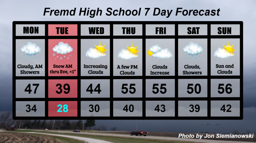
Monday 4/19: Cloudy skies along with rain showers during the morning hours will lead to cooler but overcast conditions during the afternoon and evening. Temperatures may approach freezing into Tuesday morning, which could allow spotty frost. High temperature of 47° with a low temperature of 34°.
Tuesday 4/20: Cloudy skies early in the morning with light snow arriving by late in the morning. Snow should continue in light to moderate intensity throughout the afternoon before tapering off late in the evening. Total snowfall accumulations are likely to be less than 1 inch, though locally higher amounts could be realized in areas that see a longer duration of snowfall or increased rates. Clouds will begin to thin out overnight as a potential hard freeze hits northern Illinois early Wednesday morning due to temperatures dropping into the upper 20s. High temperature of 39° with a low temperature of 28°.
Wednesday 4/21: Continued chilly temperatures with partly cloudy skies during the morning hours and increased clouds during the afternoon and evening hours. Isolated snow or mixed precipitation showers are possible throughout the day. High temperature of 44° with a low temperature of 30°.
Thursday 4/22: Generally sunny skies throughout the day along with much warmer temperatures closer to average. A period of increased cloud cover is possible during the afternoon hours. High temperature of 55° with a low temperature of 40°.
Friday 4/23: Partly to mostly cloudy skies during the first part of the day should lead to overcast skies late in the day along with the potential for a few showers late in the evening into the overnight hours. High temperature of 55° with a low temperature of 43°.
Saturday 4/24: Mostly cloudy skies along with showers during the morning may lead to a period of steady rain for the afternoon before precipitation shuts off by evening. High temperature of 50° with a low temperature of 39°.
Sunday 4/25: Partly to mostly sunny skies likely with temperatures near average. Likely the best day of the week! High temperature of 56° with a low temperature of 42°.
National Weather Headlines:
Record breaking cold temperatures are expected across much of the central United States this week as a frigid spring airmass locks itself into place for much of the week. Additionally, accumulating snow is expected for many who live in the central and eastern United States. The good news, however, is that most if not all of the snow that falls throughout eastern half of the country this week should melt within a few days.