
Fremd 7 Day Forecast: Week of 2/22/2021
February 22, 2021
Summary/Highlights:
A noticeably milder and sunnier week is in store for the Chicagoland area and will be much appreciated considering the harsh winter weather that late January and early February has featured. A cloudy start to the week on Monday and Tuesday along with temperatures closer to average in the mid to upper 30s will lead to sunnier conditions by late week with continued milder temperatures. Colder nighttime low temperatures will be possible Wednesday and Thursday nights before milder temperatures quickly take hold again. The first half of the weekend will likely be gorgeous with high temperatures near to perhaps passing 40 degrees and sunny skies. Widespread precipitation chances won’t return until Sunday, when a storm system could bring a chance for a rain and snow mix during the evening and into Monday next week. Additional small precipitation chances are possible throughout the week, especially Friday night as a weak disturbance could bring a chance for some very light snowfall. Otherwise, the upcoming week should be fairly quiet in terms of overall weather, something that many people have been looking forward to.
Daily Forecast:
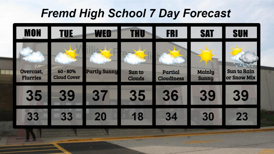
Monday 2/22: A snow shower or two is possible early before overcast skies take hold throughout the afternoon. A small chance of a snow shower or two also exists overnight. High temperature of 35° with a low temperature of 33°.
Tuesday 2/23: Partly cloudy skies early will give way to mostly cloudy skies with peeks of sunshine throughout the day. High temperature of 39° with a low temperature of 33°.
Wednesday 2/24: An even mix of sun and clouds will be present for most of the day, along with milder temperatures. High temperature of 37° with a low temperature of 20°.
Thursday 2/25: Partly to mostly sunny skies during the morning hours will lead to partly cloudy skies by afternoon with a slight chance of a snow shower late. High temperature of 35° with a low temperature of 18°.
Friday 2/26: Partly cloudy skies for the morning will lead to cloudy skies by evening as well as a chance for some light snow late. High temperature of 36° with a low temperature of 34°.
Saturday 2/27: Mainly sunny skies and temperatures near 40 degrees will make this the keeper of the week and a gorgeous day by February standards. High temperature of 39° with a low temperature of 30°.
Sunday 2/28: Partly to mostly cloudy skies in the morning may lead to increased clouds and the potential for a mix of rain and snow towards evening. This does not appear to be a major storm system. High temperature of 39° with a low temperature of 23°.
National Weather Headlines:
As parts of the South clean up from two disastrous winter storms, and the Central United States tries to unbury themselves from relentless winter weather, hope is finally in sight. Closer to average temperatures are on the horizon for many across the country as more Pacific originating air begins to enter the picture. Highs in the 40s, perhaps 50s for many, will be possible for much of the Plains and southern United States as winter appears to loosen its grip on the country. Be careful however, as there is a signal that Winter could in fact return in middle March on many of the long term weather and climate models.