
Fremd 7 Day Forecast: Week of 9/29/2020
September 30, 2020
Summary/Highlights:
We’re expecting a gloomy week ahead as we launch into the first full week in the autumnal equinox. We are likely to see temperatures well below normal, plummeting from the lower 60s early in the week to the lower 50s by the end of the week. Periodic rain chances will be present, particularly on Thursday and late in the weekend as weak disturbances in the atmosphere ride through the region, with the strongest coming through on Sunday. Patchy frost may become an issue on Saturday morning.
Daily Forecast:
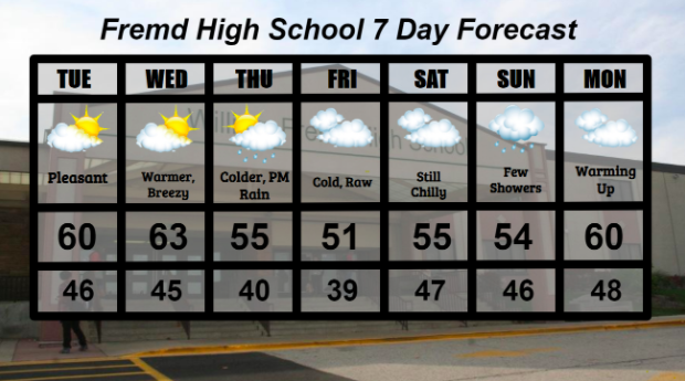
Tuesday 9/29: Pleasant but chilly day expected with mixed clouds and sunshine. High temperature of 60°, with a low of 46°.
Wednesday 9/30: Breezy with sunshine and periodic batches of clouds at times. High of 63° and a low of 45°.
Thursday 10/1: Turning colder with increasing cloud cover and a chance for a few showers by late afternoon. High temperature of 55° with a low temperature of 40°.
Friday 10/2: Much colder with mainly cloudy skies. High of 51° cooling to a low of 39°.
Saturday 10/3: Patchy frost possible in the early morning hours. Otherwise, continued cold weather with mainly overcast conditions. Rain becomes likely into the overnight hours. High of 55° falling to a low of 47°.
Sunday 10/4: Cloudy with rain showers possible. High temperature of 54° with a low temperature of 47°.
Monday 10/5: Becoming warmer with overcast skies. High temperature of 60° with a low temperature of 48°.
National Weather Headlines:
For the first time in a while, there is no tropical activity in the Atlantic Basin. This is giving much needed relief to the residents hit hard along the Gulf of Mexico this season.
Western wildfires continue to be an unfortunate story for the United States. Recent fires have now spread into Napa County in California, and have destroyed famous wineries. As crews struggle to put out the flames, new fires continue to form.