
Fremd 7 Day Forecast: Week of 5/17/2021
May 17, 2021
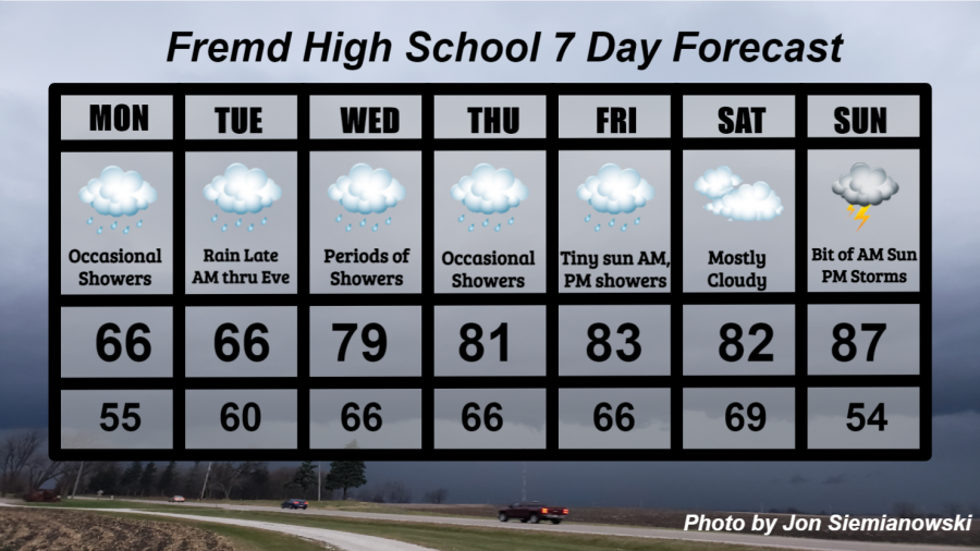
Summary/Highlights:
After a cool and dry pattern for much of April and May, things will begin to shift this week into a rainy and substantially warmer week. On Monday, expect occasional showers with temperature staying slightly below average in the middle 60s. By Tuesday, more substantial rain is expected during the day with similar temperatures. Periods of showers will continue on Wednesday and Thursday as temperatures near 80 degrees both days. Humidity will also be on the increase as temperatures rise, with a muggy feeling arriving as early as Tuesday. On Friday morning some sunshine is probable, though that sun will quickly disappear as clouds enter for the afternoon. Temperatures on Friday may be near the middle 80s as rain begins during the afternoon. That rain should clear out in time for Saturday, leaving mostly cloudy skies and muggy conditions behind. On Sunday, humidity is likely to substantially increase, leading to oppressive conditions as temperatures soar into the upper 80s. Thunderstorms will be possible heading into Sunday night as temperatures start to cool off. After the dry conditions we have experienced this spring, all of the expected rain should be beneficial to outdoor plants and animals.
Daily Forecast:
Monday 5/17: Generally cloudy skies likely with the chance for occasional light rain showers throughout the day. High temperature of 66° with a low temperature of 55°.
Tuesday 5/18: Cloudy skies during the morning hours will lead to steady rain showers during the afternoon and evening hours. Rain should begin to clear out during the late evening. Wind gusts could approach 30 mph at times. High temperature of 66° with a low temperature of 60°.
Wednesday 5/19: Much warmer and humid with cloudy skies and occasional showers throughout the day. Any rain showers are most likely during the first half of the day. Gusty winds to 35 mph may occur at times. High temperature of 79° with a low temperature of 66°.
Thursday 5/20: Very similar to Wednesday with generally cloudy skies and some rain showers during the morning and evening hours. Humidity will likely be noticeable and uncomfortable at times as gusty winds to 40 mph from the south bring in substantially warmer air. High temperature of 81° with a low temperature of 66°.
Friday 5/21: A small amount of sunshine in the morning will quickly transition to mostly cloudy skies during the afternoon with some rain showers. Humidity will be uncomfortable at times. High temperature of 83° with a low temperature of 66°.
Saturday 5/22: Mostly cloudy skies expected with the possibility of a few showers early. Muggy conditions are likely. High temperature of 82° with a low temperature of 69°.
Sunday 5/23: Partly to mostly cloudy skies for a short time in the morning will lead to increasing clouds during the afternoon and thunderstorms by evening. Humidity is likely to be nearing the oppressive category. High temperature of 71° with a low temperature of 54°.
National Weather Headlines:
While much of the Southwest deals with extreme drought conditions and fire risk, much of the Gulf of Mexico coastline and southern United States is expected to experience multiple rounds of severe thunderstorms and flooding. Repeated rounds of thunderstorms are expected to continue late week and into the weekend.