
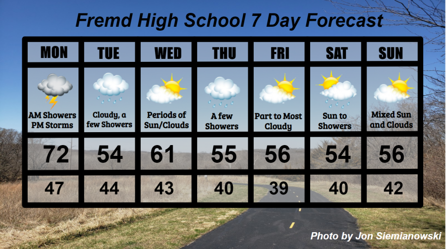
Fremd 7 Day Forecast: Week of 5/3/2021
May 3, 2021
Summary/Highlights:
After a simply gorgeous weekend for Chicago and much of the Midwest, temperatures will be on the downtrend early this week and stay there for the remainder of the week. The forecast includes some rain, most notably during the start of the week, and again in the form of a few showers later in the week. On Monday, expect showers and storms to be around, with the most numerous thunderstorms being present during the evening hours. A few storms may be strong to possibly severe as the NOAA Storm Prediction Center highlights the area under a Marginal risk for severe thunderstorms. Temperatures then drop into the 50s for Tuesday with rain showers before clearing out to a pleasant day on Wednesday. Showers may return on Thursday for a brief time throughout the day until sunshine can reappear on Friday. Partly cloudy skies can be expected for most of Friday and early Saturday, though there may be a few periods of increased cloudiness. More clouds are expected to bring overcast skies in for later in the day on Saturday which may lead to some rain showers by evening. Continued temperatures in the 50s and partly cloudy skies are then expected for late in the weekend, which could make for beautiful weather. One thing to watch for next weekend is the potential that temperatures could be warmer than forecast in advance of a new storm system. This scenario would be similar to this past weekend, when temperatures in the 60s were forecast early in the week but ultimately lead to summer-like temperatures in the 80s.
Daily Forecast:
Monday 5/3: Generally overcast skies throughout the day with showers and thunderstorms. Showers are possible during the morning hours with cloudy skies lingering into the afternoon. Later, thunderstorms are expected to develop during the evening and move into the area, bringing heavy rain and lightning. It is possible a couple storms could be strong to severe. Temperatures will be into the 70s but the humidity will make it feel slightly muggy. High temperature of 72° with a low temperature of 47°.
Tuesday 5/4: Colder temperatures expected with periods of showers, mainly during the morning and early afternoon. Otherwise, generally overcast conditions are expected. High temperature of 54° with a low temperature of 44°.
Wednesday 5/5: Partly to mostly cloudy skies with increasing cloud cover during the late evening and into the overnight hours. Slightly warmer temperatures will make this the best day of the week!. High temperature of 61° with a low temperature of 43°.
Thursday 5/6: Below normal temperatures with periods of showers, mainly during the afternoon. Cloudy skies will be around for most of the day, though may become partly cloudy for a time before the sun sets in the evening. High temperature of 55° with a low temperature of 40°.
Friday 5/7: Continued cool temperatures with partly cloudy skies. Periods of increased clouds at times may bring overcast conditions at times. High temperature of 56° with a low temperature of 39°.
Saturday 5/8: Partly to mostly cloudy skies in the morning will lead to increasing clouds and some rain showers during the afternoon and evening. Potentially well below normal temperatures are possible. High temperature of 54° with a low temperature of 40°.
Sunday 5/9: Temperatures will be on an upswing as any rain from Saturday departs early. Partly cloudy skies are expected during the day. Temperatures may end up being warmer than forecast. High temperature of 56° with a low temperature of 42°.
National Weather Headlines:
Heavy rain and severe thunderstorms are lined up for this week across parts of the Midwest, Ohio Valley, and Southeast. Flooding as well as damage from severe thunderstorms will be possible for these areas, who have already experienced a lot this season thus far.
A late season heavy snow event is on tap for parts of the northern and central Rocky Mountains early this week. This snow may be enough to cause some problems there, but the system associated with it that will move into the central United States will likely produce more damaging weather.