
Fremd 7 Day Forecast: Week of 4/26/2021
May 3, 2021
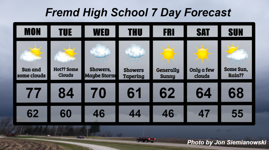
Summary/Highlights:
If you’ve been looking for weather more indicative of spring, then you’ll like what the upcoming week will bring. A warm and pleasant start to the week will give way to a stormy and slightly cooler middle of the week which should eventually balance out to multiple days with sunshine and temperatures in the 60s for the weekend. On Monday, expect temperatures pushing the upper 70s with periods of sunshine. The same goes for Tuesday, though we will likely be warming well into the 80s and perhaps setting our highest temperature so far this year! For Wednesday and Thursday, expect cooler conditions in the 60s with rain and perhaps a thunderstorm at times. Friday into the weekend should feature a lot of sunshine and temperatures in the 60s, though Sunday will be a day to watch as some of that sunshine may be cut short by an incoming storm system. Even though there are no hazards to watch out for this week, be mindful that some of the midweek rain could come down heavy for brief periods.
Daily Forecast:
Monday 4/26: Partly cloudy skies during the morning hours may lead to sunnier skies during the afternoon before a few more clouds come in for the evening. Warmer temperatures are likely along with some gusty winds from the south. This will probably be the best day of the week! High temperature of 77° with a low temperature of 62°.
Tuesday 4/27: Much warmer with temperatures into the 80s and more humid conditions likely. Partly to mostly sunny skies are expected throughout the day with an increase in cloud cover for the evening and overnight hours. Some gusty winds to 40 mph are possible. High temperature of 84° with a low temperature of 60°.
Wednesday 4/28: Generally overcast with showers and an occasional thunderstorm around. Thunderstorm chances are low, though the most likely time to experience thunder would be during the morning and evening hours. High temperature of 70° with a low temperature of 46°.
Thursday 4/29: Cooler temperatures with AM showers becoming less numerous by afternoon and tapering off for the evening. Clouds should begin clearing during the evening and give way to clear skies overnight. Some heavy rain could be possible early in the day before the rain clears out. High temperature of 61° with a low temperature of 44°.
Friday 4/30: Generally sunny skies and near average temperatures with a few clouds. Clouds are most likely during the morning hours. High temperature of 62° with a low temperature of 46°.
Saturday 5/1: Sunny skies likely with temperatures in the middle 60s and a few clouds from time to time. High temperature of 64° with a low temperature of 47°.
Sunday 5/2: Weather model solutions begin to diverge, though it is likely there will be at least some sunshine, most favored in the morning hours, Depending on the evolution of a storm system over the weekend, rain may become possible by nightfall. Temperatures are likely to be on the increase once again. High temperature of 68° with a low temperature of 55°.
National Weather Headlines:
An unseasonably warm airmass moving into the central United States early in the week will bring an increased risk for wildfires across the western Plains, as well as an increase in severe thunderstorm activity for much of the southern and central Plains, as well as the Midwest. Temperatures will fall back to averages for much of the northern and central United States late in the week before another warm-up enters the picture next week.