
Fremd 7 Day Forecast: Week of 4/12/2021
April 11, 2021
Summary/Highlights:
If you’re looking for a quiet week of spring weather, let me introduce you to the second full week of April 2021. This week will not feature much sun, but will be mostly precipitation free and will have generally consistent temperatures. On Monday and Tuesday, temperatures should generally stay in the upper 50s to around 60 degrees with periods of mixed clouds and sun likely. Some stronger winds on the order of 30 to 35 mph will also be possible throughout both of those days. As we head into Wednesday, cooler temperatures and mostly cloudy skies come into the picture. These conditions should also last into Thursday before some more sunshine and warmer weather returns for Friday. Throughout the weekend, expect partly to mostly cloudy skies and occasional chances for rain showers, mainly during the afternoon and evening hours. Thunderstorms are not expected with this shower activity.
Daily Forecast:
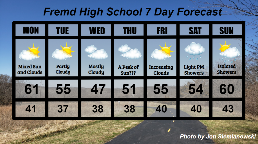
Monday 4/12: Increased cloud cover early in the day will lead to a mix of clouds and sun for the afternoon and evening hours. Some gusty winds to 35 mph are possible, though this will still likely be the keeper of the week. High temperature of 61° with a low temperature of 41°.
Tuesday 4/13: Partly cloudy skies throughout the day are likely, along with some isolated wind gusts to 35 mph. A period of increased cloudiness is possible during the evening hours. High temperature of 55° with a low temperature of 37°.
Wednesday 4/14: Generally mostly cloudy skies throughout the day with colder temperatures likely. A small window of increased sunshine is possible early in the morning. High temperature of 47° with a low temperature of 38°.
Thursday 4/15: Generally overcast with a few peeks of sun throughout the day. Temperatures will still be chilly but on a warming trend. High temperature of 51° with a low temperature of 38°.
Friday 4/16: Partly cloudy skies during the morning hours will lead to cloudy skies by evening as clouds increase through the day. Slightly warmer temperatures are probable. High temperature of 55° with a low temperature of 40°.
Saturday 4/17: Mainly cloudy skies throughout the day with random peeks of sunshine. Some light rain showers may be present during the afternoon and evening hours, but the precipitation won’t add up to much of anything. High temperature of 54° with a low temperature of 40°.
Sunday 4/18: Partly to mostly cloudy skies with isolated to scattered shower activity. Milder temperatures are expected, but thunderstorms are not likely. High temperature of 60° with a low temperature of 43°.
National Weather Headlines:
Heavy rain and flooding is expected across portions of the South, Mid-Atlantic, and Northeast regions of the United States this week as a large weather system is poised to produce hefty amounts of rainfall in those regions. Cumulative rainfall of 1 to 2 inches is a possibility.
A quiet week of severe weather is ahead for much of the United States. This is great news considering the large amount of severe weather events that have occurred over the southern part of the country over the past two months.