
Fremd 7 Day Forecast: Week of 3/8/2021
March 15, 2021
Summary/Highlights:
A roller coaster ride of a week in terms of weather is in store for the second full week of March as we sit about two weeks away from the start of the spring equinox. The week will start off with mostly sunny skies on Monday, followed by gradually increasing cloudiness into Tuesday and into Wednesday. By the middle of the week, expect temperatures climbing into the lower to middle 60’s before rain enters the picture. There is a concern for flooding on Thursday, as heavier rain and thunderstorms may move through over the already melted snowpack and areas that will receive light rain on Wednesday. Beyond Thursday, temperatures look to fall back towards daily averages before potentially below average temperatures come back for a visit late in the weekend. A storm system on Sunday and into early next week could bring a chance for mixed precipitation. Due to the overall nature of spring storms and their greater intensity due to battling air masses, it would not be a surprise to see some snow at times, potentially accumulating. Details on the weekend storm will become more available and clear throughout the week, so make sure to stay tuned to local media for more information.
Daily Forecast:
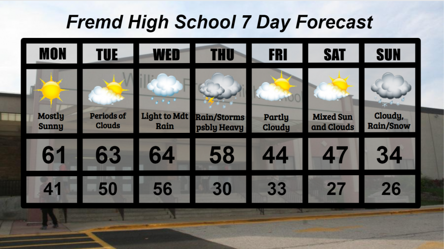
Monday 3/8: Mostly sunny skies likely with very mild temperatures. High temperature of 61° with a low temperature of 41°.
Tuesday 3/9: Even milder temperatures combined with winds gusting over 30 mph at times and periods of sunshine and clouds should make for a beautiful day. High temperature of 63° with a low temperature of 50°.
Wednesday 3/10: Another warm day with temperatures pushing the middle 60s is likely. A chance for light to moderate rain will exist throughout the day along with gusty winds over 40 mph at times. Rain could continue overnight. High temperature of 64° with a low temperature of 56°.
Thursday 3/11: Mild morning temperatures in the 50s will drop through the day as a cold front brings rain and thunderstorms. There is the possibility of heavy rain, which could lead to some flooding issues due to the high moisture content in the soil. Rain should clear out by late in the evening hours. High temperature of 58° with a low temperature of 30°.
Friday 3/12: Noticeably colder and quieter with mixed clouds and sunshine. High temperature of 44° with a low temperature of 33°.
Saturday 3/13: Slightly warmer temperatures with periods of partial cloudiness. High temperature of 47° with a low temperature of 27°.
Sunday 3/14: Much colder with rainy conditions as the next storm system approaches. There is the potential for a mix of rain and snow at times. While the chances of accumulating snowfall are low, spring storm systems can often be stronger than they seem. Therefore, this will be something to watch over the next week. High temperature of 34° with a low temperature of 26°.
National Weather Headlines:
Much of the United States will remain quiet in terms of weather over the next few days before rain barrels across much of the country late in the week. Warm to record warm temperatures have settled in across much of the central United States, with records likely being broken for parts of the northern Plains and upper Midwest.
High elevation snow continues for parts of the northwest United States and northern California, affecting these areas through at least early in the week.