
Fremd 7 Day Forecast: Week of 2/15/2021
February 21, 2021
Summary/Highlights:
A milder week filled with more sunshine than we have seen over the last couple of weeks is on tap as drier weather moves in. After a winter storm that brought nearly half a foot of snow to the northern suburbs of Chicago, as well as upwards of a foot of snow in the city and lakefront, things will become a lot quieter. A more in depth discussion of the winter storm can be found later in this article. For the middle of the week, there will be intervals of clouds and sunshine, with temperatures climbing into a more manageable range. Thursday will bring cloudy skies and milder temperatures pushing the middle 20s along with a chance for some snow. Significant accumulations are not expected, but I cannot rule out an inch or two of snow falling on the high end. As we head into the weekend, expect mixed clouds and sunshine at times, with temperatures increasing into Sunday where a mix of rain and snow is possible as temperatures finally warm above freezing.
Daily Forecast:
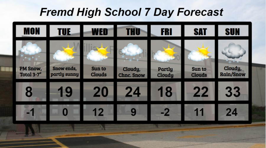
Monday 2/15: Mainly cloudy skies likely with snowfall, heavy at times, by evening. A Winter Storm Warning is in effect for all of Cook county, due to the potential of 4 to 8 inches of snow, and near 12 inches of snow for locales bordering the lake. Due to the highly variable nature of lake effect snowfall, it is hard to predict precise accumulations. The main message is to be prepared for heavy snow. Snow will continue overnight with frigid temperatures. High temperature of 8° with a low temperature of -1°.
Tuesday 2/16: Snow ends early, with the Winter Storm Warning expiring at 12 PM. Total snowfall accumulations of 5 to 10 inches expected. Skies may temporarily clear during the day to give way to partly cloudy skies at times. High temperature of 19° with a low temperature of 0°.
Wednesday 2/17: Sunshine likely early before clouds increase into the afternoon and evening. There is a slight chance of a snow shower or two.. High temperature of 20° with a low temperature of 12°.
Thursday 2/18: Cloudy conditions with periodic chances for snow. Depending on the track of the system responsible, forecast snowfall totals are between 0 and 2 inches. High temperature of 24° with a low temperature of 9°.
Friday 2/19: Intervals of clouds and sunshine with manageable air temperatures. High temperature of 18° with a low temperature of -2°.
Saturday 2/20: Mainly sunny skies early will lead to widespread clouds by afternoon or evening. High temperature of 22° with a low temperature of 11°.
Sunday 2/21: Overcast skies likely with a chance for rain or snow, as well as a mix. High temperature of 33° with a low temperature of 24°.
National Weather Headlines:
A quiet and warmer week is in store for much of the United States as people from North Dakota to Texas and up through the Northeast look for relief from the “crazy” weather of the weekend and early week. Several inches of snow fell in Texas, along with ice and frigid temperatures elsewhere across the South. Widespread damage and pile-ups occurred through the South due to this extreme weather.
Winter Storm of 2/14 to 2/16/2021:
A large winter storm recently moved across the southern and central parts of the United States, bringing endless impacts and numerous problems. First let’s start locally in Chicagoland where this storm is certainly one for the record books. During the evening and overnight hours of February 14th, light snow overspread the Chicago area bringing a widespread 1 to 2 inches of snow, which wasn’t much compared to what this winter season has brought so far. The next day, February 15th, the second part of the snowstorm arrived, bringing fierce winds and moderate to heavy snow across the Chicago area. The heaviest of the snow was located in the far eastern sections of the area into the overnight and morning hours of February 16th. Lake effect was a huge component to the storm, as several heavy lake effect snowfall bands drifted on and off of the Chicago and Cook county shorelines, as well as other coastal areas in Illinois and Indiana. By the time all was said and done, a widespread 4 to 10 inches of snow had fallen across Cook county and northwest Indiana, with areas closer to the lakefront seeing snowfall totals in the 12 to 18 inch range. Residents of Chicago and other communities near the lakefront spent all morning shoveling and snow blowing their way out of what had fallen. An official snowfall of 7.5” was the grand total at Chicago O’Hare International Airport, with West Ridge and Oak Park the highest totals in the area at 18.6 inches of snow.
- Additional information about this snowfall event can be found on the National Weather Service Chicago website: https://www.weather.gov/lot/Feb14-16_HeavySnow
Elsewhere across the United States, southern states arguably got hit the hardest from this winter storm. In addition to crippling amounts of ice that left trees and power lines down across the deep south, up to a foot of snow was reported in parts of Texas, Oklahoma, Missouri, Arkansas, and areas points northeast into Michigan, Pennsylvania, and New York. Due to winter weather this extreme not being very common in some of these southern areas, roads were extremely treacherous, and many were left without power, heat, or water for days. An additional 4 to 8 inches of snow and upwards of a half an inch of ice is expected to hit many of the same areas in the South affected by this previous damaging storm.