
Fremd 7 Day Forecast: Week of 2/1/2021
February 2, 2021
Summary/Highlights:
After a very active weekend involving the major winter storm that slammed much of the Chicagoland area with 8 to 12 inches of snow, a quieter week is in store for us to start February. A more detailed discussion of the 1/30 to 1/31 winter storm is located towards the end of this article. The first half of the week should bring mild and pleasant conditions, with sunshine at times likely. By Thursday, temperatures should increase to nearly mid 30s before a weak storm system delivers a small round of light snowfall into Thursday night. Snow, perhaps mixing with rain at times, could accumulate with current indications suggesting 1 to 4 inches of snow likely. Tranquil weather will follow on Friday with any light snow ending early and temperatures plummeting. The weekend will feature yet another couple of chances for light snowfall before the bottom drops out on temperatures from Sunday into early next week. Current indications suggest that sub-zero temperatures are likely, with the potential for temperatures to reach well below zero at times. Dangerous wind chills will be common, with the current forecasted temperatures being on the conservative side. Looking into the long term forecast, colder than average temperatures look to prevail through mid-month.
Daily Forecast:
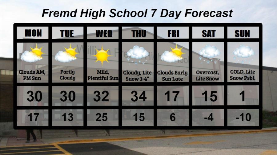
Monday 2/1: Clouds early will give way to periods of sunshine during the afternoon hours. High temperature of 30° with a low temperature of 17°.
Tuesday 2/2: Mixed clouds and sun likely with continued mild temperatures. High temperature of 30° with a low temperature of 13°.
Wednesday 2/3: Warmer temperatures and mainly sunny skies will make for a gorgeous day and the keeper of the week. High temperature of 32° with a low temperature of 25°.
Thursday 2/4:Clouds early will give way to light snow beginning midday. Some rain could mix in, especially during the daytime hours. Total snow accumulations of 1 to 4 inches are likely. High temperature of 34° with a low temperature of 15°.
Friday 2/5: Clouds and perhaps a few snow light snow showers early will lead to partly cloudy skies by the afternoon. Sharply colder temperatures are likely. High temperature of 17° with a low temperature of 6°.
Saturday 2/6: Very cold temperatures with the potential for some light snow showers during the day. High temperature of 15° with a low temperature of -4°.
Sunday 2/7: Coldest weather of the season likely beginning today through early in the week. Some snow is possible, with little to no accumulation expected. Wind chills could approach dangerous levels. High temperature of 1° with a low temperature of -10°.
National Weather Headlines:
The same storm system that brought up to a foot of snow across Chicagoland moves east early in the week, affecting areas of the Mid-Atlantic and Northeast United States. Snowfall could be tallied in feet with 10 to 20+ inches of snow possible for areas under Winter Storm Warnings.
Very cold temperatures, perhaps to dangerously cold levels, are possible next weekend and beyond across much of the northern United States as polar air sinks southward across Canada. While this arctic event likely won’t live up to the standards of the January 2019 arctic event, it may still place much of the northern US at risk for dangerously cold temperatures and wind chills.
1/30 – 1/31 Winter Storm Discussion:
On the evening of Jan. 30, 2021, a powerful winter storm began to impact Chicagoland, bringing storm totals of 8 to 12+ inches of snow in many areas. This powerful storm created hazardous travel conditions due to fast rates of snow accumulation, with snowfall rates of 1 to 2 inches per hour a common sight across northern IL on the evening of January 30th. The heaviest of the snow fell between roughly 7 PM and 12 AM that evening, with up to 6 inches of snow falling for many during just those 5 hours. Light snowfall continued throughout the overnight hours and well into January 31st, with lake effect snowfall increasing across Illinois lake-bordering counties. By late in the evening on January 31st, a majority of the storm had passed, leaving widespread snowfall of 8 to 12 inches, locally higher for some. Due to brisk winds at times, snowfall drifts of up to 2 feet were common.
The National Weather Service commented on the storm as it wrapped up on Jan. 31, detailing that 8.8” of snow had fallen at Chicago O’Hare International Airport as of 12 PM, making it the second snowfall event in a week that produced 6+ inches of snow. The last time that happened was in January of 2014, or 7 years ago! This number also made this snowfall the first time in over 5 years to have a 2-day snowfall total this high, with the last time being November 20th and 21st of 2015 which clocked in at 11.2” officially at O’Hare. Continued snowfall accumulation throughout the day likely added to the official storm total at O’Hare Airport, therefore making 8.8” the unofficial storm total until it is updated.