
Fremd Seven Day Forecast: Week of 1/25/2021
January 27, 2021
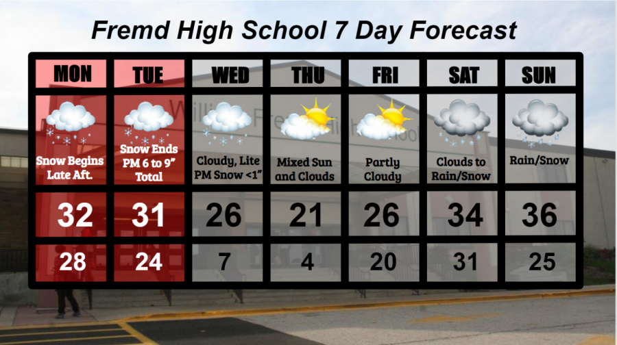
Summary/Highlights:
A very active weather week is on tap for the area as multiple storm systems bring both chances for snow and very cold air into the picture through the end of next weekend. The first storm system will be a potent storm, bringing widespread accumulating snowfall to the Chicagoland area during the first part of the week. A Winter Storm Warning is in effect from Monday at 4 PM until Tuesday at 5 PM. Widespread snowfall amounts between 5” and 8” are currently forecasted, with isolated 10” snowfall totals possible. After this storm system departs, attention shifts towards a small disturbance passing through the area midday on Wednesday. While not a big storm, this disturbance could lay down a quick half inch of snow and bring in significantly colder air as it exits the region. Overnight low temperatures late in the week could fall well into the single digits, creating potentially hazardous wind chills below 0 degrees and general inconveniences. Temperatures should begin to moderate into the weekend with yet another storm system entering the Midwest. A mix of rain and snow is currently expected over the weekend with this storm system, though cannot rule out any accumulating snow completely.
Daily Forecast:
Monday 1/25: Cloudy conditions throughout the morning and afternoon hours will give way to snow by evening as a winter storm enters the area. A Winter Storm Warning goes into effect at 4 PM Monday evening. Heavy snow, combined with gusty winds at times, will create hazardous travel conditions and near blizzard conditions at times. Snow will continue overnight. High temperature of 32° with a low temperature of 28°.
Tuesday 1/26: Continued moderate to perhaps heavy snow at times during the morning hours. Light snow will continue through the evening. The Winter Storm Warning will expire at 5 PM. Lake enhancement to some of the snow could boost snow totals in portions of Cook County. Total snowfall accumulations of 5 to 8 inches expected with isolated higher amounts possible. High temperature of 31° with a low temperature of 24°.
Wednesday 1/27:Continued cloudiness with the potential for a round of some light snow in the afternoon hours. Total snow accumulations from this should be minimal and less than an inch. Cold temperatures settle in overnight. High temperature of 26° with a low temperature of 7°.
Thursday 1/28: Continued cold with mixed clouds and sun at times. High temperature of 21° with a low temperature of 4°.
Friday 1/29: Generally partly cloudy skies with cold temperatures are expected. High temperature of 26° with a low temperature of 20°.
Saturday 1/30: Increasing clouds throughout the morning hours will lead to snow and eventually a mix of rain and snow by evening. High temperature of 34° with a low temperature of 31°.
Sunday 1/31: Continued sloppy weather conditions likely with rain and snow throughout the day. High temperature of 36° with a low temperature of 25°.
National Weather Headlines:
A potent storm system will affect portions of the Midwest early this week with heavy snow. Southern portions of Nebraska and Iowa, along with northern portions of Kansas, Missouri, and Illinois will be affected with periods of heavy snow through Tuesday. Winter Storm Warnings have been posted for these areas, which could see up to a foot of snow.
Cold conditions are forecast to settle into the Midwest and northern Plains states as the aforementioned storm system departs the area. Sub-zero temperatures are possible in many areas as single digit low temperatures and lower affect most if not all of the Midwest.