
Fremd 7 Day Forecast: Week of 1/18/2021
January 27, 2021
Summary/Highlights:
The upcoming third full week in January will feature many days with sunshine as well as colder temperatures than we have been accustomed to so far this winter. Focusing on the beginning of the week, it is likely we will remain mostly cloudy with colder conditions and chances for flurries and light snow showers. For the middle of the week, expect the sun to return and continue to stay through late in the week, with some clouds beginning to mix in towards the weekend. Colder air should begin to enter our area by the weekend but will be partially halted by a storm system entering the picture late in the weekend and into early next week. This storm system should bring widespread overcast skies as well as a chance for snow. While the magnitude of the snowfall event next weekend is uncertain, there is a definite possibility that we could see some accumulating snow in or around the general area. Any accumulating snow will be welcome by snow lovers, considering how quiet the season has been thus far in terms of higher end snowfalls.
Daily Forecast:
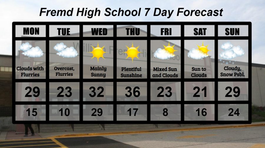
Monday 1/18: MLK day! Temperatures will be on the chillier side with mainly cloudy skies and scattered snow flurries. High temperature of 29° with a low temperature of 15°.
Tuesday 1/19: Continued overcast conditions with light snow showers at times. High temperature of 23° with a low temperature of 10°.
Wednesday 1/20: Sunshine returns as temperatures warm up to near freezing. High temperature of 32° with a low temperature of 29°.
Thursday 1/21: Largely sunny skies and warmer temperatures makes this the keeper of the week. High temperature of 36° with a low temperature of 17°.
Friday 1/22: Mostly cloudy skies early should lead to periods of sun and clouds throughout the afternoon. A sharp drop in temperatures is likely, perhaps leading to single digit air temperatures by Saturday morning. High temperature of 23° with a low temperature of 8°.
Saturday 1/23: Mainly sunny skies early will lead to increasing clouds and eventually mostly cloudy skies by evening. High temperature of 21° with a low temperature of 16°.
Sunday 1/24: Overcast conditions likely with the potential for snow, possibly accumulating snow. High temperature of 29° with a low temperature of 24°.
National Weather Headlines:
A strong high pressure will drop south from Canada into the northern Plains and eventually the Midwest late this week, bringing cold air with it. Sub-freezing high temperatures will be possible in the far northern Plains with the potential for single digit high temperatures across much of the northern Plains and Midwest for one or two days.
A storm system will ride through the middle of the United States late this week, bringing accumulating snow to its north, and thunderstorms to its south. Much of the country has yet to see a major winter storm, but it appears that this storm will probably not be that impactful. Severe thunderstorms could be possible across portions of the Gulf of Mexico states with this storm system.