
Fremd 7 Day Forecast: Week of 1/11/2021
January 14, 2021
Summary/Highlights:
A generally mild, though cloudy week is expected with a couple of chances for precipitation, mainly in the form of snow. After a week of little to no sun, many are getting excited ahead for any chance of more sun this week. Unfortunately, sunshine will be limited again this week, with the best chances of sunshine being confined to early in the week. Temperatures will continue to stay mild for January until a storm system on Friday brings in more seasonable temperatures. The storm system on Friday is likely to produce some snow across the area, though exact amounts and impacts are unclear. Stay tuned to local news and media for the latest information on that storm system. Clouds should continue into the weekend with colder air entering the region. It is possible that a few flurries or light snow showers could occur on Sunday. January is historically one of the cloudiest months in Chicagoland, so it is no surprise that the sun has been limited.
Daily Forecast:
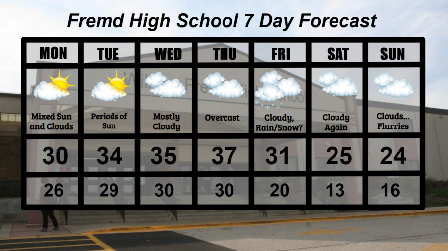
Monday 1/11: Mixed clouds and sun throughout the day, with periods of increased clouds. High temperature of 30° with a low temperature of 26°.
Tuesday 1/12: Partly cloudy skies likely with the potential for periods of mostly sunny skies. This combined with warmer temperatures makes this the keeper of the week. High temperature of 34° with a low temperature of 29°.
Wednesday 1/13: Cloudy skies return with slightly warmer temperatures and a couple periods of mixed sunshine possible. High temperature of 35° with a low temperature of 30°.
Thursday 1/14: Overcast conditions likely throughout the day as the next storm system enters the Midwest. Warmer temperatures likely with a chance for some light rain or snow during the evening and overnight hours. High temperature of 37° with a low temperature of 30°.
Friday 1/15: Cloudy conditions with rain or snow, though more likely snow, will become possible on Friday as a potent storm system sweeps through our area or just to the north of our area. Snowfall accumulations will likely be on the lighter side with some minor travel impacts possible. Temperatures dropping throughout the day will make way for colder conditions over the weekend. High temperature of 31° with a low temperature of 20°.
Saturday 1/16: Cloudy, but cooler conditions expected with increased winds out of the northwest ushering in colder air. High temperature of 25° with a low temperature of 13°.
Sunday 1/17: Nearly a carbon copy of Saturday with cloudy skies and cold temperatures and a chance for flurries. Snowfall accumulations likely won’t amount to much. High temperature of 24° with a low temperature of 16°.
National Weather Headlines:
A zonal flow is likely over much of the United States for the upcoming week as Pacific air creates milder than average conditions and cloudy skies across much of the northern states. It won’t be until late week that this zonal flow begins to break down and allow for more intrusions of cold air. A storm system is likely to bring colder air to the northern states along with a chance of snow for some late in the week. While it does not look like a major storm system, portions of the Midwest can expect to see some minor impacts from snow. Otherwise, it will remain fairly quiet across much of the United States this week.