
Fremd 7 Day Forecast: Week of 12/28/2020
January 4, 2021
Summary/Highlights:
A wild week in weather is shaping up as we close out 2020 and begin 2021. Two large and disrupting storm systems are forecast to affect the area with all four possible modes of precipitation being possible. After a somewhat tranquil start to the week on Monday, clouds will be on the increase throughout the day on Tuesday before a band of heavy snow develops Tuesday evening. That snow will eventually transition to freezing rain, better known as ice, as we approach Wednesday. Freezing rain is a mode of precipitation where it appears to be raining, but because surface temperatures are below freezing, the rain freezes on contact onto outside surfaces, including roads, trees, and power lines. There may be a brief changeover to all rain as temperatures near the freezing level before the storm ends on Wednesday afternoon. A winter weather advisory has been issued by the National Weather Service (NWS) in Chicago for the combined storm impacts of snow accumulation and minor ice accretion. Thursday will feature quiet weather and some sun in the sky before another complex weather system enters the region on Friday, New Years Day. As of the writing on 12/28, it appears that the storm on Friday will again feature more snow, ice, and sleet, transitioning to rain before ending as snow. Due to continued minor changing in the forecast, accumulations of any frozen precipitation remain unclear. Saturday and Sunday will both be quiet with partly cloudy skies and manageable temperatures for early January.
Daily Forecast:
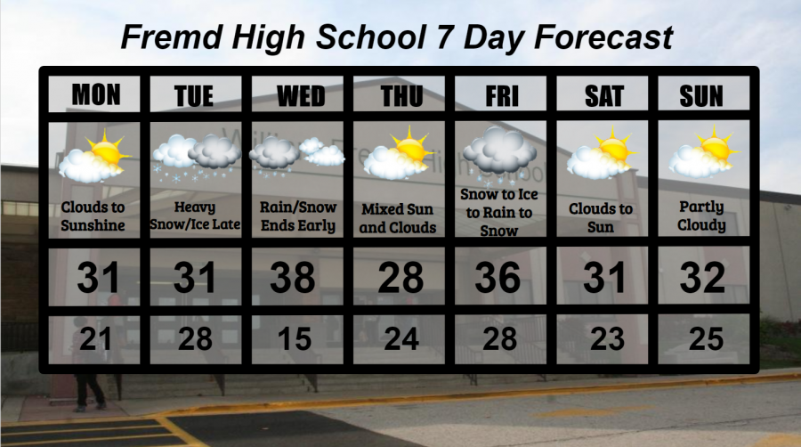
Monday 12/28: Clouds early will lead to plentiful sunshine by the afternoon. High temperature of 31° with a low temperature of 21°.
Tuesday 12/29: Increasing clouds throughout the day will give way to heavy snow during the evening hours. A transition to ice will likely occur overnight. Total ice accumulations of around 0.10” and total snow accumulations of 2” to 4” can be expected. A winter weather advisory has been issued by the NWS in Chicago for light ice and snow accumulations. High temperature of 31° with a low temperature of 28°.
Wednesday 12/30: Rain and snow mix will end by afternoon, leaving overcast skies for the rest of the day. High temperature of 38° with a low temperature of 15°.
Thursday 12/31: Mixed clouds and sun throughout the day with colder temperatures. High temperature of 28° with a low temperature of 24°.
Friday 1/1/2021: Snow very early in the morning will transition to freezing rain and likely rain eventually. Any snow/ice accumulations will likely melt with any rain, though it is important to specify that any changes in the forecast could impact local weather considerably. High temperature of 36° with a low temperature of 28°.
Saturday 1/2: Clouds early will lead to mostly sunny skies by afternoon. A few flurries or brief snow showers are possible at times. High temperature of 31° with a low temperature of 23°.
Sunday 1/3: Mixed clouds and sun are likely throughout the day with seasonal temperatures. High temperature of 32° with a low temperature of 25°.
National Weather Headlines:
Two weather systems are forecast to affect the entire United States this week with strong winds, heavy snow, and ice accretions. The first will occur early in the week with significant snow accumulations possible across parts of Iowa, Wisconsin, and northwest Illinois. A zone of icing is also expected across portions of these areas. Significant travel delays and impacts are possible, with winter storm warnings and winter weather advisories already posted by the NWS. The second storm system is expected to affect much of the United States from Thursday into Saturday. Not only will New Years travel be interrupted, but significant winds and snow, as well as ice, are possible with this system across portions of the Midwest. It is still unclear how this system will affect certain areas, so stay posted to local news and media for the latest as winter begins to show its true power.