
Fremd 7 Day Forecast: Week of 12/21/2020
January 4, 2021
Summary/Highlights:
A weather rollercoaster ride of a week is expected with temperatures varying considerably at times throughout the forecast period along with a large spread in weather conditions expected. A fairly quiet start to the week will lead up to a mild day on Wednesday 12/23, followed by a strong push of cold air Wednesday evening, bringing a sharp drop in temperatures and the potential for a flash freeze. A flash freeze can be dangerous as rain from earlier in the day freezes where it lies as temperatures drop below freezing within hours, leading to icy streets, sidewalks, and outdoor objects. Cold conditions will continue following the flash freeze through Friday 12/25 before more milder temperatures enter the picture for the weekend. A white Christmas that so many have dreamed about for 2020 does not appear to be in Chicago’s card deck this year. The potential exists for a mix of rain and snow on Sunday 12/27, perhaps some accumulating snow, though uncertainty precludes any further explanation of details. The forecast extending beyond this week looks to favor temperatures near average and above average precipitation chances.
Daily Forecast:
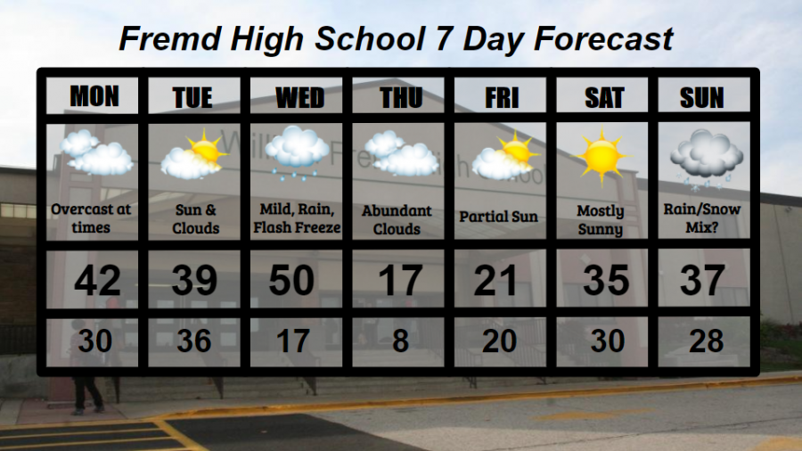
Monday 12/21: Overcast at times with breezy conditions and the potential for a few sprinkles. High temperature of 42° with a low temperature of 30°.
Tuesday 12/22: Fair with mixed clouds and sun for most of the day. High temperature of 39° with a low temperature of 36°.
Wednesday 12/23: Mild temperatures to start the day with temperatures reaching near 50 before a strong cold front moves through, dropping temperatures by nearly 35 degrees over 12 hours. Rain is likely before the front passes through, leading to the potential for a flash freeze as temperatures quickly drop. High temperature of 50° with a low temperature of 17°.
Thursday 12/24: Cold temperatures and mainly cloudy conditions through the day are likely. High temperature of 17° with a low temperature of 8°.
Friday 12/25: Merry Christmas! Partial sunshine returns as temperatures warm slightly, though still cold. High temperature of 21° with a low temperature of 20°.
Saturday 12/26: Mostly sunny skies accompany much warmer temperatures. High temperature of 35° with a low temperature of 30°.
Sunday 12/27: Mostly cloudy conditions are likely with a chance for a mix of rain and snow. The potential exists for some accumulating snow as well. High temperature of 37° with a low temperature of 28°.
National Weather Headlines:
Winter Storm Watches have been issued for portions of New York, North Dakota, and Minnesota where snowfall accumulations in the coming day are likely to exceed winter storm criteria. These areas, as well as areas of the northeast that saw up to 4 feet of snow last week, are likely to see a White Christmas. For the rest of the country, however, it’s looking like the grass will remain green.