Fremd 7 Day Forecast: Week of 12/7/2020
December 6, 2020
Summary/Highlights:
A seasonable though chilly start to the week is forecast followed by increasing temperatures later in the week as a storm system brings 40s and perhaps 50s into the area from the south. The upcoming week will likely feature dry conditions through Friday before a cold front approaches the area, bringing a chance for a soaking rain to start the weekend. A sharp temperature drop will follow as the cold front moves through the area on Saturday, leading to decreasing temperatures throughout the day. Unseasonably cold air then looks to take residency in the region late in the weekend into next week, where temperatures will likely be 5 to 10 degrees below average. While snow potential throughout the week is expected to be generally low, there is the potential for a snowstorm somewhere in the region which must be watched carefully. Should the expected snowfall from this storm shift further south, Chicago may be in the path of a winter storm on Saturday or Sunday. However, since it is too early to tell, the main message is to be prepared for at least some snowfall over the weekend. The National Weather Service (NWS) Climate Prediction Center (CPC) currently forecasts a return in above normal temperatures into the middle of the month.
Daily Forecast:
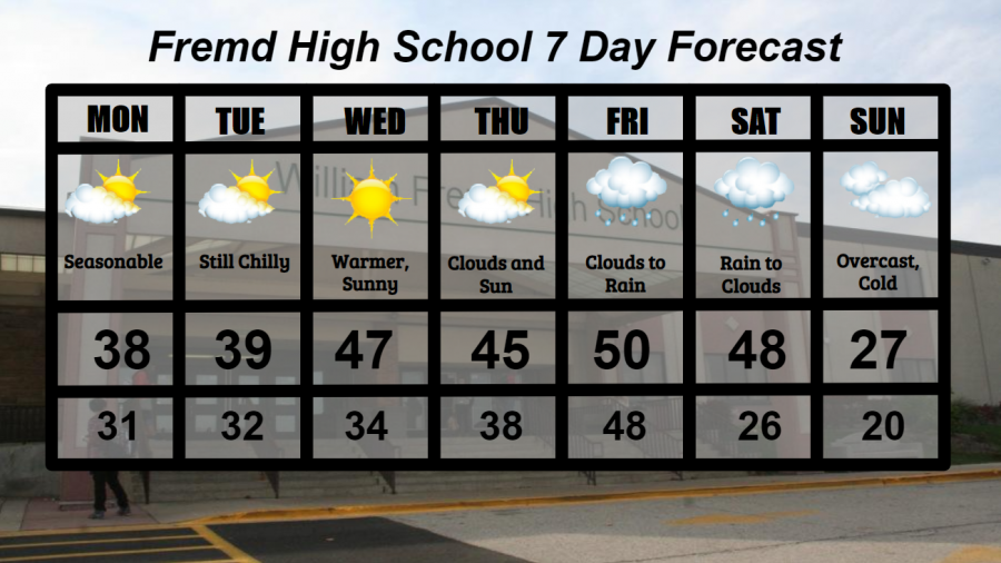
Monday 12/7: Clouds and sun mixed throughout the day, with seasonable temperatures. High temperature of 38° with a low temperature of 31°.
Tuesday 12/8: Partly cloudy skies likely for most of the day, though more sun than clouds are expected. High temperature of 39° with a low temperature of 32°.
Wednesday 12/9: Becoming warmer with abundant sunshine. High temperature of 47° with a low temperature of 34°.
Thursday 12/10: Sunshine and clouds mixed, still warmer. High temperature of 45° with a low temperature of 38°.
Friday 12/11: Clouds early, then becoming mild as south winds increase. Rain will become likely by late afternoon with occasional breezy conditions. High temperature of 50° with a low temperature of 48°.
Saturday 12/12: Rain early will likely transition to a mix of rain and snow or all snow by the afternoon as temperatures plummet throughout the day. Snowfall accumulations are uncertain at this distance, though should be watched. High temperature of 48° with a low temperature of 26°.
Sunday 12/13: Unseasonably cold temperatures with overcast conditions. High temperature of 27° with a low temperature of 20°.
National Weather Headlines:
A storm system will move across the United States late in the week, bringing adverse weather conditions to many as well as a brief increase in temperatures for some. A snowy side will be present to this storm, with snowfall accumulations possible in the northern Plains. As of 12/8, model projected snowfall accumulations have shifted further south. While nothing is for certain, many in the Midwest could see accumulating snow this weekend if this new trend should verify.
Multiple weather systems appear likely to affect a majority of the United States over the next 2 weeks. While it is unclear what impacts will be present, when they will occur, and who will be impacted, it does appear that snowfall accumulations, potentially significant, could impact the Plains and Midwest during this timeframe. Although there is nothing to worry about presently, these weather systems must be watched.