
Fremd 7 Day Forecast: Week of 11/23/2020
November 23, 2020
Summary/Highlights:
An unsettled and cool week is expected as we head into the last full week of November with temperatures generally around average and multiple chances for precipitation. Some sun on Monday will be short-lived as a storm system approaches on Tuesday. Precipitation will likely fall in the form of snow, possibly including minor accumulations, early Tuesday before transitioning to rain as temperatures warm up during the day. Rain will continue on Wednesday with continued overcast conditions through Thursday. The sun will return for the first half of the weekend before yet another storm system affects the area late in the weekend and early next week, bringing another chance for rain and potentially some snow.
Daily Forecast:
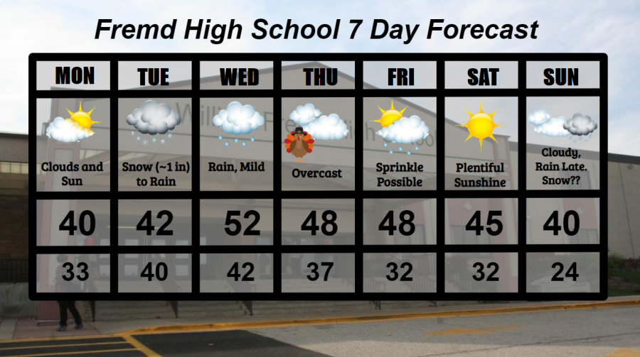
Monday 11/23: Sun and clouds mixed throughout the day. High temperature of 40° with a low temperature of 33°.
Tuesday 11/24: Snow, potentially heavy at times, in the morning hours will transition to rain showers as temperatures warm into the 40s. Snow accumulations of up to 1 inch are possible before afternoon rain melts the snow. High temperature of 42° with a low temperature of 40°.
Wednesday 11/25: Continued rain showers are likely throughout the day as southerly winds warm temperatures above average. High temperature of 52° with a low temperature of 42°.
Thursday 11/26: Happy Thanksgiving! Overcast conditions linger with a slight chance of a rain shower early. High temperature of 48° with a low temperature of 37°.
Friday 11/27: Sun and clouds mixed throughout the day. Periods of increased cloudiness are possible. A slight chance of a rain shower cannot be ruled out. High temperature of 48° with a low temperature of 32°.
Saturday 11/28: Plentiful sunshine and near average temperatures will easily make this the best day of the week! High temperature of 45° with a low temperature of 32°.
Sunday 11/29: Mainly cloudy conditions earlier in the day will likely lead to rain showers by evening and a more persistent rainfall into Monday. Due to forecast temperatures in the 30s and the likely close proximity of the rain/snow line for this storm system, snow showers and even some light accumulating snowfall are possible. However, high uncertainty exists as to the occurrence of any snow around this timeframe. High temperature of 40° with a low temperature of 24°.
National Weather Headlines:
For the first time in what seems like a long time, there is no tropical activity to worry about in the Atlantic basin. In addition to this, no tropical activity is forecast within the next 7 days. This is great news considering the window is closing for any meaningful tropical activity.
Multiple storm systems are forecast to move across the United States in the next 10 days. Given the time of year, these storm systems are likely to have a messy side to them, with snow becoming more and more likely in the northern United States as we get closer to the winter season.