Fremd 7 Day Forecast: Week of 10/20/2020
October 21, 2020
Summary/Highlights:
A very unsettled week of weather is forecast for the upcoming week as multiple storm systems move through the region. Temperatures this week are challenging to forecast as these storm systems contain many different fronts, or sudden changes in temperature over a short distance, which can affect temperatures greatly. However, the most uncertainty is present for the weekend of 10/24 into early next week as a large storm system enters the region. After a gradual warming trend early in the week leading to 70s by Thursday, temperatures remain rather uncertain for the weekend with current indications supporting 50s for high temperatures.
Daily Forecast:
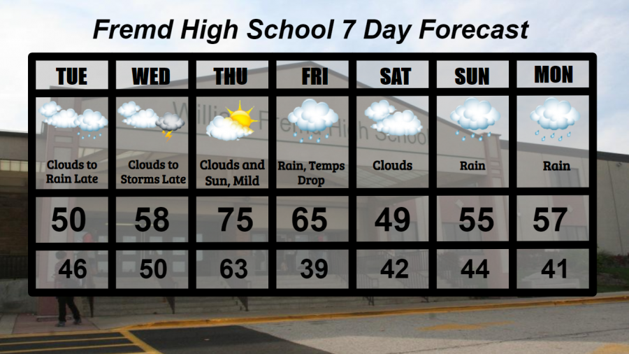
Tuesday 10/20: Mainly cloudy skies with rain becoming likely later at night. High temperature of 50°, with a low of 46°.
Wednesday 10/21: Overcast conditions throughout the day will lead to increasing humidity and thunderstorms at night. High of 58° and a low of 50°.
Thursday 10/22: Mild conditions with periods of clouds and sun. Skies may shift between overcast and sun throughout the day. High temperature of 75° with a low temperature of 63°.
Friday 10/23: A morning high temperature in the 60s will drop throughout the day with overcast conditions and a chance for rain. High of 65° cooling to a low of 39°.
Saturday 10/24: Overcast conditions with cooler conditions. High of 49° falling to a low of 42°.
Sunday 10/25: Cloudy skies with rainy conditions. Large temperature swings are possible today. High temperature of 55° with a low temperature of 44°.
Monday 10/26: Continued rainy conditions with overcast skies. Large temperature swings may occur. High temperature of 57° with a low temperature of 41°.
National Weather Headlines:
A storm system sweeping across the United States this week will bring the first real threat of accumulating snow to the northern states.
Warm conditions return to California and the Southwest, increasing fire danger from the west coast into the plains and perhaps midwest. Numerous storm systems moving throughout the central US should help to keep most of the fire risk confined to the western states.