Fremd 7 Day Forecast: Week of 10/05/2020
October 7, 2020
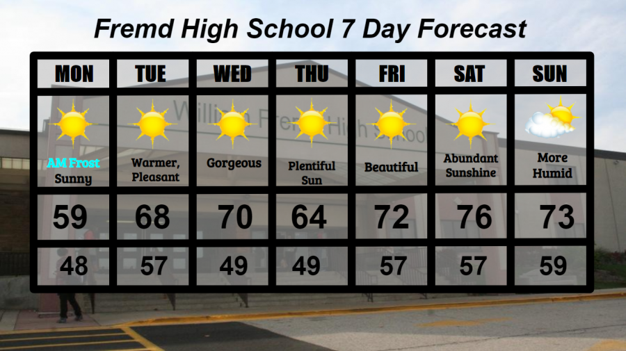
Summary/Highlights:
A gorgeous week is expected to materialize for the first full week in October. Temperatures rising into the 70s by late week combined with abundant sunshine will provide for a rain-free and spectacular week. The first real threat of widespread frost will occur on the morning of Monday 10/5 as temperatures dip into the middle 30s across northeast IL. Sunshine and breezy southerly winds late in the week will help to increase humidity levels by late in the weekend, though the higher humidity levels will be manageable.
Daily Forecast:
Monday 10/5: Frost likely in the early AM hours. Then turning warmer with mainly sunny skies during the day. High temperature of 59° with a low temperature of 48°.
Tuesday 10/6: Seasonable warmth with plentiful sunshine and pleasant conditions. High temperature of 68° with a low of 57°.
Wednesday 10/7: A gorgeous day consisting of largely sunny skies with the possibility of a few passing clouds. High of 70° and a low of 49°.
Thursday 10/8: Continued abundant sunshine with slightly cooler temperatures. High temperature of 64° with a low temperature of 49°.
Friday 10/9: Perfect day expected with sunshine and a passing cloud or two. High of 72° with a low of 57°.
Saturday 10/10: Much warmer with mostly sunny conditions. High of 76° falling to a low of 57°.
Sunday 10/11: Continued warmth with increasing amounts of humidity. Sun and clouds mixed throughout the day will provide for another fantastic day. High temperature of 73° with a low temperature of 59°.
National Weather Headlines:
Continued hot and dry conditions in the western half of the United States continue to spread and ignite new fires across the west coast and into the plains. The forecast pattern provides no relief, as extended warmth will continue over the region.
Tropical Storm Gamma is currently spinning in the southern Gulf of Mexico, and currently poses no threat to the United States. This may change into next week as the storm turns north towards the US, as intensity is unclear.
Potential Tropical Cyclone Twenty-Six (as of Sunday 10/4) is moving northwest into the Gulf of Mexico. This cyclone is expected to form into a hurricane, likely affecting the Louisiana coast later this week. While future intensity or impacts are unclear, it nevertheless poses a threat to the United States towards the weekend.