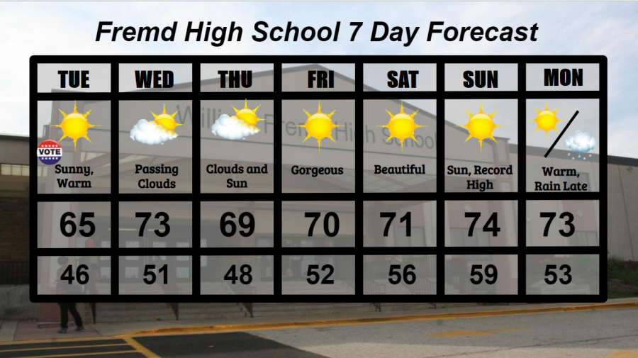
Fremd 7 Day Forecast: Week of 11/03/2020
November 4, 2020
Summary/Highlights:
An unseasonably warm and gorgeous week is expected this week as southerly winds and clear skies will support high temperatures in the 60s and lower 70s through Monday. Mid 70s are possible on Sunday, potentially breaking the daily record high temperature of 73° set in 1931 at Chicago O’Hare Airport. Election day on Tuesday 11/3 looks to be beautiful with sunny conditions and mild temperatures, a trend that will continue into the weekend. More unsettled weather is likely early next week as a storm system enters the region. This storm system will likely bring a sharp temperature drop on Tuesday with rain early next week. A colder, more unseasonable pattern looks to set up into next week, so enjoy the warm weather while it lasts.
Daily Forecast:
Tuesday 11/03: Election Day! Sunny skies and southerly winds will make for a beautiful day. High temperature of 65°, with a low of 46°.
Wednesday 11/04: Continued warmth with some passing clouds, though mainly sunny. High of 73° and a low of 51°.
Thursday 11/05: A mix of clouds and sun likely with unseasonably warm temperatures. High temperature of 69° with a low temperature of 48°.
Friday 11/06: Mainly sunny skies with much warmer temperatures compared to early in the week. High of 70° cooling to a low of 52°.
Saturday 11/07: A gorgeous day with plentiful sunshine. High of 71° falling to a low of 56°.
Sunday 11/08: Another keeper of a day with temperatures close to 20 degrees above average and mainly sunny with clouds increasing throughout the day. Record high temperatures possible. High temperature of 74° with a low temperature of 59°.
Monday 11/09: Warm and cloudy early leading to partly cloudy skies late. Another day of temperatures near 20 degrees above average. High temperature of 73° with a low temperature of 53°.
National Weather Headlines:
Tropical Storm Eta sets its gaze on northeastern Nicaragua Tuesday as a Category 5 hurricane. Eta marks the 28th tropical storm system in the Atlantic hurricane season, tying the previous record for the most named storms in a season, which occurred in 2005. This is the first time, however, that Eta has been used in the Greek Alphabet. Eta may eventually turn around and head for Florida or other northeastern Gulf of Mexico states next week.
Unseasonably warm temperatures are expected to spread into the western, central, and eventually eastern United States this week as a ridge of high pressure moves across the country. This warm-up comes just a week after an unseasonably cold end to October across parts of the northern United States.


